


Voting District 30240, Kern County, California
About
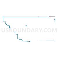
Outline

Summary
| Unique Area Identifier | 531901 |
| Name | Voting District 30240 |
| County | Kern County |
| State | California |
| Area (square miles) | 2.69 |
| Land Area (square miles) | 2.69 |
| Water Area (square miles) | 0.00 |
| % of Land Area | 100.00 |
| % of Water Area | 0.00 |
| Latitude of the Internal Point | 35.43174220 |
| Longtitude of the Internal Point | -119.05518470 |
Maps


Graphs
Select a template below for downloading or customizing gragh for Voting District 30240, Kern County, California


Neighbors
Neighoring Voting District (by Name) Neighboring Voting District on the Map
- Voting District 10435, Kern County, CA
- Voting District 10440, Kern County, CA
- Voting District 10445, Kern County, CA
- Voting District 10490, Kern County, CA
- Voting District 10495, Kern County, CA
- Voting District 30195, Kern County, CA
- Voting District 30200, Kern County, CA
- Voting District 30205, Kern County, CA
- Voting District 30255, Kern County, CA
- Voting District 30260, Kern County, CA
- Voting District 30265, Kern County, CA
- Voting District 30270, Kern County, CA
- Voting District 30275, Kern County, CA
- Voting District 30315, Kern County, CA
- Voting District 30320, Kern County, CA
Top 10 Neighboring County Subdivision (by Population) Neighboring County Subdivision on the Map
Top 10 Neighboring Place (by Population) Neighboring Place on the Map
Top 10 Neighboring Elementary School District (by Population) Neighboring Elementary School District on the Map
- Norris Elementary School District, CA (23,935)
- Standard Elementary School District, CA (22,909)
- Beardsley Elementary School District, CA (17,072)
Top 10 Neighboring Secondary School District (by Population) Neighboring Secondary School District on the Map
Top 10 Neighboring State Legislative District Lower Chamber (by Population) Neighboring State Legislative District Lower Chamber on the Map
Top 10 Neighboring State Legislative District Upper Chamber (by Population) Neighboring State Legislative District Upper Chamber on the Map
Top 10 Neighboring 111th Congressional District (by Population) Neighboring 111th Congressional District on the Map
Top 10 Neighboring Census Tract (by Population) Neighboring Census Tract on the Map
- Census Tract 1.01, Kern County, CA (12,240)
- Census Tract 2, Kern County, CA (7,644)
- Census Tract 5.03, Kern County, CA (6,347)
- Census Tract 5.04, Kern County, CA (4,086)
- Census Tract 39, Kern County, CA (2,250)